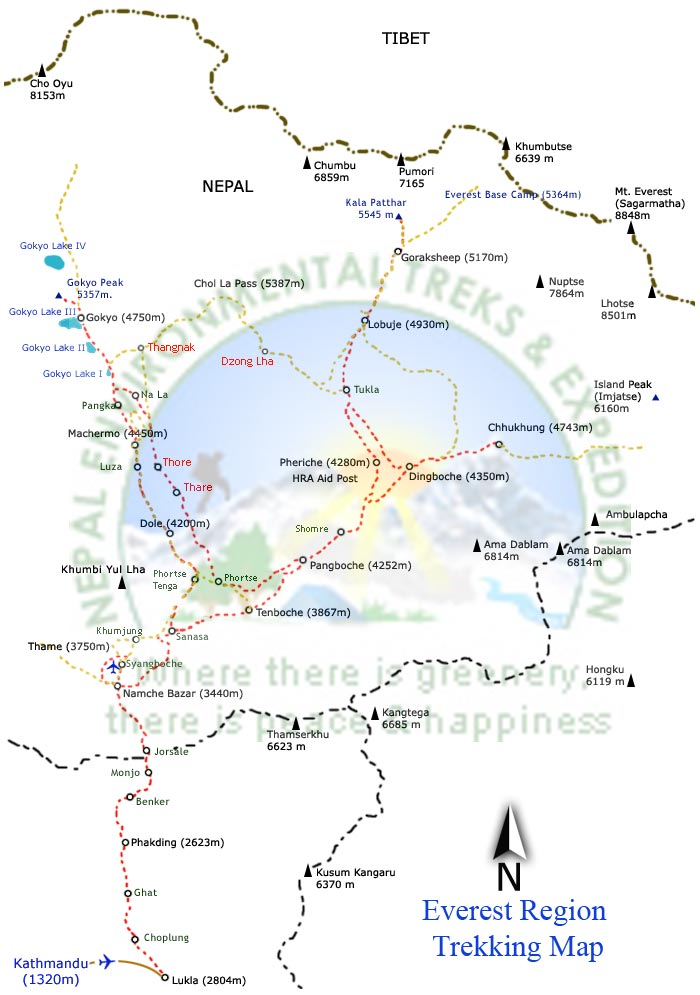
The Jiri-EBC-Kalapathar Trek is less crowded as most people fly to Lukla and walk only the high-altitude portion of the route. The Jiri-EBC trek from Jiri involves a tremendous amount of walking hillsides. The trek climbs to the ridge that separates two rivers, descends to the river itself, and then ascends the next ridge.
Jiri-EBC trek begins at an elevation of 1860m. The Everest region is not only famous for its proximity to the world’s highest mountain, Mt. Everest (8848m.) but also for its friendly Sherpa people, picturesque villages, great variety of cultures and traditions, colorful festivals and monasteries. The flora and fauna are other ornaments of the Sagarmatha National Park. The story of the yeti, which is still a mystery in the world, is also embedded in Khumbu region.
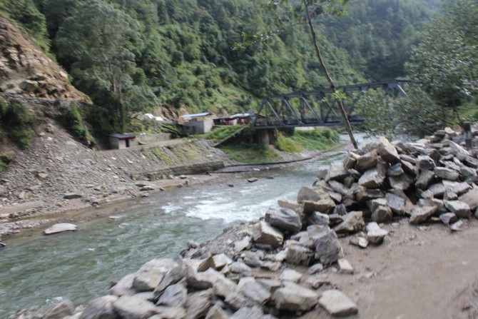
The first part of your journey drives eastwards from Kathmandu passing through Bhaktapur, Banepa, Dhulikhel, Dolalghat, Lamasanghu and part of the Araniko Highway before turning right on the road to Jiri, which passes through green hilled scenery as well as snow capped mountains. The road is quite narrow but it is smooth. Jiri is a town named after Jirel, the majority people inhabited in and around the town.
The beginning of your trek is a gentle ascent for the first two hours to Mali Danda (2440m.) and then it follows a gently descending path to Shivalaya (1800m.) where you can take lunch and hang around. After your lunch, the trail turns steeply up before turning into a gentle ascent to Deorali. You can enjoy the green scenery as well as some of the snow-capped mountains at a far distance.
The starting of your trek is a steep descent for early an hour to Bhandar (2250m.) and then a gentle descent to Kenja (1600m.) where you can enjoy your lunch. After your lunch, your trek is goes steeply up to your destination. En route, you can enjoy the agricultural farm scenery where locals are always working hard. In addition to this, you pass through Sherpa villages with beautiful mountain views.
To begin your trek, you climb steeply for an early two hour passing through Dagchu and Goyem, small Sherpa settlements. Then your trek starts gently up to the Lamjura Pass (3500m.) through rhododendron forest. After the pass, the rest of the trek is a gentle descent to your destination. On this route, you can enjoy viewing some of the snow capped mountains such as the "Goa of the Solu" along with spotting some wildlife such as monkeys and many species of birds.
Take the day to enjoy the cultural surroundings and the beautiful scenery, or you can visit Thubten Chholing Monastery known as Nunnery Monastery on a two hour side trip after 3 days of hard trekking.
The beginning of your trek is a gentle ascent for early one and half hours to Phurtung (2900m.). From this place, you can see your first views of Mount Everest, Thamserku (6623m.), Kantega (6780m.), Kusum Kangaru (6370m.) and Mera Peak (6650m.) Your trek is flat and a gentle descent to Ringmo Khola (2500m.). Immediately, your trail goes steeply up for one and half hours to the Takshindo La Pass (3100m.). From this point, you can see excellent mountain views. At the end of your trek is a steep descent to the town of Nunthala (2200m.) through a small Sherpa settlement and forest.
The beginning of your trek is a gentle descent to the Dudh Koshi river (Milk River) for an early two hours passing through agricultural farm land and small Sherpa and Rai settlements. From the Dudh Koshi river, your trail is a gentle ascent all the way to Kharikhola (2050m.) passing through Juving (1680m.) a pretty big Rai village and farming lands. From Kharikhola your trail follows a flat path for 45 minutes and then steeply up to the camp (Bupasa) where you can visit a Buddhist Monastery in ruined state.
At the beginning of the day, you ascend steeply for the early two hours to Khari La Pass (2880m.). While trekking you pass through rhododendron and oak forests, including a small Sherpa settlement and teashops. From this point, you can see excellent views of different mountains such as Numbu (6960m.), Cho-oyu (8201m.), Gyangchung Kang (7922m.) and Thamserku (6629m.). Now, your trail is a gentle descent and flat to Chaubar (2730m.) passing through Bamboo forests and Puiyan (2770m.) with views of the Khumbu Valley as well as beautiful mountains. At the end of the day, your trail steeply descends to your destination. Surkey is a small Sherpa village at the bottom of Lukla.
The first part of the trek is a gentle ascent for early 2 hours to Chhiplung (2700m.), a junction road to Jiri and Lukla passing through Mushe (2650m.). From this place, the road is quite broad and busy. Now, your trail is almost flat and gently descends before ascending again to Phakding. This is a short trek after 3 long days on the trail. You can hang in and around Phakding village.
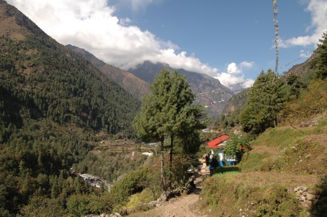
This day you trek and cross the river on high suspension bridges. Beyond Monjo(2800m.) is the entrance to the Sagarmatha National Park which was set-up in order to protect and preserve this fragile mountain environment. You then ascend quite steeply to Namche and along the way, if the weather is clear, catch a glimpse of Mt Everest in the distance. You can also enjoy views of Mt. Kusum Kangaru, Thamserku, Konde-Ri and Tawache peak. Another highlight to this day is being able to visit some of the village monasteries on the way to Namche Bazaar (3440 m.). Namche is the main trading village in the Khumbu region and holds a busy Saturday market.
Namche is tucked away between two ridges amidst the giant peaks of the Khumbu and has an abundance of lodges, teashops and souvenir shops as well as a magnificent outlook. It is an ideal place to spend a rest day for acclimatization to the high altitude before heading off towards Tyangboche. For acclimatization you walk up to Khunde Hospital, which was set-up by Sir Edmund Hillary, or a one hour walk up to Syangboche (3800m.) where Everest View Hotel is situated above Namche for outstanding views of Everest, Nuptse, Lhotse, Ama Dablam, Thamserku and Kusum Kangaru. There are also good views from the National Park Center and Museum just above the town.
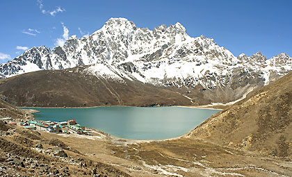
Leave the village for a climb to the top of a ridge and level mountain path that offers an excellent panorama of Thamserku, Kantega, and Kusum Kangrib. To the right there is a steep cliff that drops down to the Dudh Kosi, faintly visible on the valley floor below. Make your way around a branch ridge, and Ama Dablam (6812m) Everest, Lhotse, Nuptse (7855m) and Tawetse (6501m) suddenly appear. After a gentle descent the mountain path ends and you will come to the fork leading to Gokyo. Descend past two tea houses and through the village of Trashinga. Though you cannot see it, you can hear the Dudh Kosi and soon you descend to the river and arrive at Phunki Tenga. It is a long climb to Tyangboche; the first half is especially steep. As you climb through the forested zone, the incline eases and splendid views appear. Continue climbing the mountainside diagonally until you come to the stone gate built by lamas which marks your entry into Tyangboche (3860m). You may use the large plateau in front of the splendid monastery as your campsite. There is also a lodge and hotel managed by the National Park Service. Tyangboche is an important lookout point on this course, and the sunset on Everest and Ama Dablam is especially beautiful
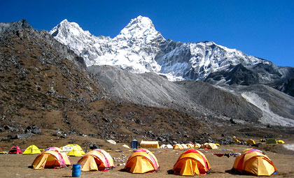
Leave Tyangboche and the Khumbu mountains as a backdrop-and descend a rhododendron covered area to emerge to a pleasant level area. Pass a long Mani stone wall to enter the village of Deboche. Go on to Minlinggo and leave the mountain path to cross over a suspension bridge to the left bank of the Imja Khola. Climb the mountain path while looking up at Ama Dablam and Kantega (6779m) appears on the opposite bank. Ascend the chorten-lined route, come to a fork, the upper path passes Pangboche and a monastery, take the lower path to Pangboche Olin and its stone wall-enclosed potato field. Pass through the village and cross a stream to a path skirting a rocky area to terraced hills along the riverbank. The trail climbs slowly, winding above the Imjatse River, to a big Mani Stupa. From here, the walk is fairly moderate as you enter the Imjatse Valley beneath the mighty peaks of Ama Dablam, Nuptse and Lhotse with views of the eastern snow capped mountains including the Island Peak or Imjatse (6,189m) Dingboche is a beautiful patchwork of fields enclosed by stone walls protecting the crops of barley, buckwheat and potatoes from the cold winds and grazing animals.
There are some breathtaking views of the North face of Ama Dablam and the Lhotse-Nuptse ridge as we explore this beautiful valley that leads up to Island Peak. The walk is short with a good chance to relax in the afternoon.
The onward journey leads north for up to 50-minutes until you come to a mani-prayer Stupa. The trail is gentle looking down to Pheriche village below. Today's walk offers views of the Mt.Tawache, Ama Dablam and to the north-Pokalde (5741m) Kongma-tse (5820m) and the great wall of Nuptse. After 1 ½ to 2 hours walk, the trail from Pheriche joins near Dugla (4595m) before a small wooden bridge over the river of the Khumbu glacier. Stop at Dugla, for lunch, before continuing for an hour up a steep hill to the top, where there are views of Mt. Pumori and other peaks west of Everest. After a short break, continue (1 ½ to 2 hours) of trekking up to Lobuche which is hidden and sheltered from the wind.
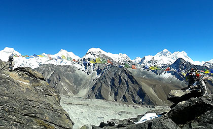
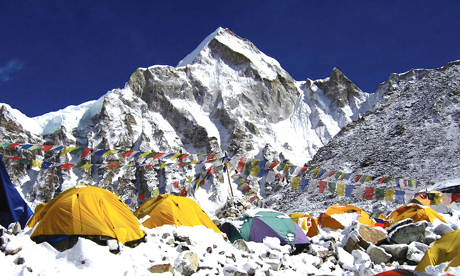
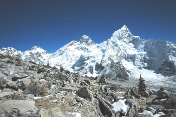
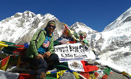
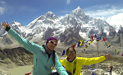
Trek up the valley following the rocky moraine path, view an icy glacial pond and icebergs down below the Khumbu glacier. After the last rocky moraine dunes, a short downhill walk brings you to Gorakshep, the flat field below Kala Patthar (5545m) and Mt. Pumori (7145m.). Gorakshep is the location of the original Everest Base Camp with the new camp being further up the valley. Now the trail winds through a rocky path and Khumbu glacier. The view of Nuptse, Lho-La and Khumbutse appear at the front of you. Sometimes an avalanche can be seen along the way. After a picturesque moment, you retrace your path back through the Khumbu glacier with magnificent views of Lobuche, Cholatse, Mt. Pumori and Tabuche.
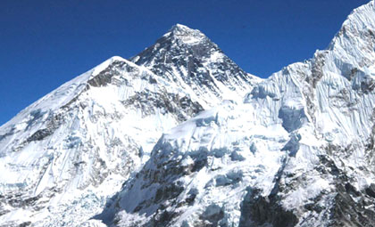
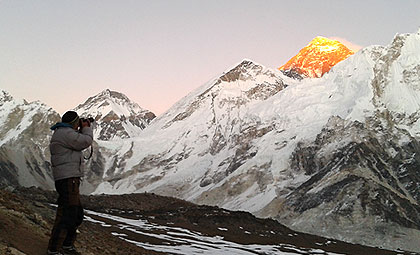
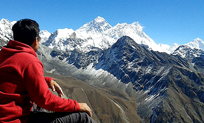
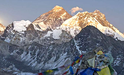
Enjoy an early morning climb to Kala Patthar (5545m.) and enjoy the view of the spectacular sunrise. From Kala Patthar you can have a panoramic view of Mt. Everest and many other mountain peaks like Mt. Pumori, Mt. Lingtren, Mt. Khumbetse, Mt. Nuptse, Mt. Lhotse, Mt. Ama Dablam, Mt. Thamserku and many others.
Pheriche is a place where you can make phone calls to any part of the world. You can also see the mountain yaks in Pheriche, which are normally regarded as the porters in this area. The town of Pheriche is known as windy town. There you can see the perpendicular walls of Cholatse and Tawache. Here is also located the Himalayan Rescue Association Aid Post where foreign volunteer doctors are stationed to provide medical treatment to trekkers as well as local people.
Enjoy a morning visit to the research center, then trek back to Tyangboche, an easier descent passing through rhododendron forest. Tyangboche is a small village with a famous monastery offering you splendid views of Ama Dablam, green hills and river views.
The walk from Tyangboche is mostly downhill on the main busy trail with a few steep climbs for an hour from the bridge at Phungitenga, near Shanasha. The walk to Namche is very scenic on a long winding path. Along the way you will visit the traditional villages of Khumjung and Khunde, and have an opportunity to visit a special monastery, the only monastery that has a Yeti Scalp. From Khumjung village another 30 minutes walk brings to the village of Khunde, where you can visit the Khunde Hospital funded by the Sir Edmund Hillary Trust. After Khunde, a scenic and pleasant walk brings you to Namche for the overnight stay.
The trail descends gently for some distance. En route you pass a few villages, terraces and enjoy the beautiful mountain views. From Chhuplung the trails again move down until Surkey via Chaurikharka, a relatively big village mainly inhabited by Sherpa. Moreover, you find mani walls, chorten, monastery and significant Sherpa culture. To describe Surkey, it is apt to mention that it lies at the bottom of hill. It is surrounded by forests covered with pine and oaks.
To reach Phuiyan La you follow an ascending path passing through a few trees. The trail now stretches out on a flat level until you reach Phuiyan where there are human settlements of Rai and Sherpa people. It is surrounded by forests. Leaving this village, you gently ascend crossing a small stream to reach Kharte Danda. En route, you pass through bamboo and oak forests. Then your journey starts descending until you reach Bupsa. On the way, you find some tea houses and feel exhilarated at the sight of natural vegetation.
The early part of your trek to Kharikhola is a steep descent. Kharikhola is a big village mainly inhabited by Rai, Sherpa and people of other castes. You find terraces, schools and the way to Mera Peak used by climbers. The trail now goes downwards to Jubing and you cross the Dudh Koshi over the suspension bridge. You then begin to follow an ascending path passing through forests covered with rhododendron, oaks, pine and other natural vegetation. To reach Nunthala, you follow the same ascending path. It is a village occupied by Sherpa, Rai and other castes. There is a handicraft factory where trekkers can visit.
This day you begin your trek following a steeply ascending path through forests until Trogsindho. There is a beautiful, old monastery here. You can enjoy mountain views of Thamserku (6623m.), Kantega (6780m.), Kusum Kangaru (6370m.) and Mera Peak (6650m.). While ascending, you cross Trogsindho La. Here you see chorten, mani walls and prayer flags fluttering in the breeze. You can enjoy a few tea shops available here. The green scenarios compel you to fall in love with nature. Leaving this place, you descend to Ringmu where there is an apple orchard and terraces. Passing through this village, you reach Sallung Danda. Here is situated a cheese factory and you can enjoy views of Everest, Thamserku, Mera Peak, Makalu, Kusum Kantega and local villages at some distance. To reach Junbesi, you have to go down way through bare hills and pine forests before you cross a small stream. Junbesi is a big village, rich in Sherpa culture and home to a monastery, school, hydro power project, communication facilities and fruits and vegetable gardens.
The early part of the trails goes upward and then stretches at a flat level until Tractor. You enter a village here with a monastery, chorten and terraces. To reach Lamjura, you follow a steeply ascending path crossing forests covered with rhododendron, pine and oak trees. There are a few tea shops in and around this area. Now you descend all the way to Sete through rhododendron and oak forests. Sete is a small village with chorten, prayer flags and terraces.
You walk downwards all the way to Kenja (1600m.) passing through villages, terraces and green hills. The Solukhumbu district ends at Kenja and Ramechhap district starts from here. The inhabitants belong to different community. The trails now turn upward until you reach Bhandar, a beautiful big village with good sceneries, monastery, tea garden, terraces, weekly market and communication facilities. To reach Deurali, you ascend all the way passing through forests covered with oak and other natural vegetation. From here, you enjoy the spectacular view of Gaurishankar. Deurali is a Sherpa village is surrounded by forests and displaying chortens, mani walls and prayer flags fluttering in the breeze.
The beginning part of your trek is a steep descent to Shivalaya through forests, villages and terraces. There is actually a motorway to Shivalaya, but some disruptions occur during the monsoon season. This village is densely populated by a mixed community. As you cross a stream over a suspension bridge you head upwards for Mali Gaon (Mali village). From here you see green hills and fields where people grow wheat, millet, maize and green vegetables. Leaving Mali Danda you begin your trek to Jiri following some ups and downs along the way. Jiri is a town named after Jirel, the majority people inhabited in and around the town.
Drive from Jiri to Kathmandu which takes about nine hours.
Below is a list of equipment and clothing required for trekking. The necessity of these items depends on the type, altitude, timing and destination of trekking. Appropriate trekking gears are not only required for the comfort/pleasure of your trek but also to improve safety factor. Please have a look over these items in order to fully prepare and thoroughly enjoy the trekking.
General Items:
Daypack, Rucksack, Sleeping bag, Duffel bag, Walking Poles, walking boots, sandals, Toiletries (Soaps, Toilet papers, Sanitizers, toothpaste, tooth brush, etc.)
Clothing Items:
Thermal underwear, Down jacket, Shorts, Trekking trousers, Towels, Woolen gloves, Gaiters, Fleece jacket or Pullover, Wind/water proof jacket, Raincoat, Warm socks, buff
Sun-worn Items:
Sun hat, Sunglasses, Snow goggles, Sunscreen, Lip balm
Gadgets:
Headlamp, Flash light, Binoculars, Cameras (chargers and batteries),
Liquid/Snacks:
Water bottle/bladder, Water purification Iodine tablets, Energy bars and snacks
Medical Essentials:
First Aid Kit
Optional:
Altimeter, Compass, Binoculars, Books/magazines, GPS, Pocket knife, Candles (for lodges), Notebook with pencil/pen, etc
Additional items for camping trek:
Tent, Stove and fuel, Utensils for cooking, eating and drinking, sleeping mattresses
Note: We can also provide sleeping bag, down jacket, duffel bag, walking poles, and First Aid Kit in case if you don’t have one. These items are inclusive of total package price.
Clemens, Martin & Roman
29th Jun, 2022
HIMALAYA TREKKING 2010 Himalaya trekking 2010 from Lukla to Gokyo Ri, Chola Pass, Everest Base Camp and Kala-Patthar. Address: Austria
Travis Allan Wagner , Amber Dawn Seelig , Kay Ellen Seelig ,Russell John Seelig , Adrienne
29th Jun, 2022
Everest Base Camp Trek from Jiri The walk was long and the rain was hard but we preserved andever finally got done. Hey folks- its one footing front of the other. But what happened to the ‘Welcome to Everest Base Camp’ flag?Thanks for everything. Address: USA


Quick Response, Personalized Information
Nepal , Everest Trek Packages 7 Days
Nepal , Everest Trek Packages 16 Days

Nepal , Everest Trek Packages 26 Days