Snowman trek is a 28 day long trek program in the wilder region of Bhutan, the land of Thunder Dragon. Enthusiasts recognize this trek as the toughest trek in the world because of its altitude, distance, climate and remoteness. At the same time, the Lunana region of Bhutan is one of the most beautiful areas of the world and the least visited.
It takes tough and enduring trekkers into the Lunana region and further on to Gangkhar Puensum and Bumthang or down to Sephu in Trongsa district, depending on which route you choose. The Snowman trek leads through the most remote areas up to very high altitudes. Trekkers have to camp in altitudes above 5,000m more than once, and depending on the seasonal temperatures, the camps are sometimes on snow.
The Lonely Planet describes the Snowman Trek as one of the most difficult treks of the world. Many groups that attempt this tough trek do not actually finish it due to problems with the high altitude or snow blocked passes. Therefore, the best time for the Snowman Trek – unlike the other high altitude treks of Bhutan – is in summer time. Still, those who make it will remember this trek as an outstanding beautiful and maybe as the most rewarding trek of their life.
Day 01: Arrive Paro
Day 02: Paro Sightseeing
Day 03: Drukgyel Dzong – Sharna Zampa
Day 04: Sharna Zampa- Thangthangkha
Day 05: Thangthangkha – Jangothang
Day 06: Jangothang – Lingshi
Day 07: Lingshi – Chebisa
Day 08: Chebisa – Shomuthang
Day 09: Shomuthang – Robluthang
Day 10: Robluthang – Limithang
Day 11: Limithang – Laya
Day 12: Rest/Acclimatization day in Laya
Day 13: Laya – Rhoduphu
Day 14: Rhodophu – Narethang
Day 15: Narethang – Tarina
Day 16: Tarina – Woche
Day 17: Woche-Lhedi
Day 18: Lhedi-Thanza
Day 19: Rest day at Thanza.
Day 20: Thanza – Danji
Day 21: Danji – Tshochena
Day 22: Tshochena – Jichu Dramo
Day 23: Jichu Dramo – Chukarpo
Day 24: Chukarpo – Thampe Tsho
Day 25: Thampe Tsho – Maurothang
Day 26: Maurothang – Sephu
Day 27: Wangdue – Thimphu
Day 28: Thimphu – Paro Airport
The flight to Paro is one of the most spectacular of all mountain flights. One can see Mt. Everest, Kanchen Junga, Makalu and other peaks in Bhutan such as Chomolhari, Jichu Drakey and Tsrim Khang. The first gift from Bhutan will be cool, clean fresh air as you step out of the plane. You will be received by our representative and escorted to the hotel.
Morning hike up to the Taktsang monastery (Tiger’s nest). The climb up to the viewpoint will take around 3 hours. Enjoy the stunning view of the monastery where Guru Padmasambava landed on the back of a tigress in the 8th century, and meditated for three months. The monastery was later built in this holy place in 1684. After tea in the café walk back to the road point and drive to hotel for lunch. Afternoon visit the Ta-dzong built in the 17th century, as watchtower to defend Paro dzong below. This dzong was converted into the National Museum in 1967, and is filled with antique thanka paintings, textiles, weapons and armour. Driver to the Rinpung dzong, built in the 17th century to defend the valley against Tibetan invaders. The dzong is now used as an administration center and school for monks. Overnight at Paro.
Distance 17km, four to five hours, 360m ascent, 80m descent, camp altitude 2,850m.
Drive up to Drukgyel Dzong (2,580m) where the road ends and the trek begin. With a gradual climb the trail follows the Paro Chhu passing beautiful meadows, paddy fields and impressive farm houses. After about four hours you will reach the army post at Gunitsawa village. At the army checkpost your trek permit (provided by your tour operator) will be checked and endorsed. The campsite is on the opposite side of the river, not far from Gunitsawa.
Distance 22km, seven to eight hours, 770m ascent, 10m descent, camp altitude 3,610m.
On this long day, the trail continues with lots of small ups and downs. After goinguphill through the river valley , you enter the Jigme Dorji National Park. The valley finally narrows gradually to a mere path which descends to a meadow where a camp will be set up. From here, if weather permits, you will have the first great view of Mount Jomolhari.
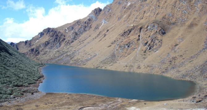
Distance 19km, five to six hours, 480m ascent, camp altitude 4,080m). If you did not see Mount Jomolhari last evening, you will have a great chance to get a great view this early morning. This morning the trek continues up the Paro Chhu valley which widens into patches of alpine meadow and scanty growths of forest. Cross an army outpost along the way and enjoy a spectacular view of high mountain ridges and snow-capped peaks. Yaks and the herder’s homes become a regular feature of the landscape. Passing the villages Soe, Takethang and Dangochang is another asset on this day. Reaching Jangothang, one of the most beautiful campsites of the Himalayas, you will again have a spectacular view of Mount Jomolhari.
Distance 18km, six to seven hours, 840m ascent, 870m descent, camp altitude 4,010m.
After 15 min. from the camp the trail climbs rapidly for about half an hour and then becomes a gradual ascend to the Nyilila pass at 4,870m. While on the climb enjoy the sourrrounding. You might see herds of blue sheep grazing on the slopes of the mountains. From the pass you will
have spectacular views of Mt. Jomolhari, Jichu Drake and Tsherimgang, all of them rising above 7,000m. On the way down to the camp you will pass by some of the yak herder’s tent, made from yak wool, where the herders take shelter while on the move to various pastures for their yaks. As you come down into the Lingshi basin, you get a wonderful view of Lingshi Dzong on a clear day. Tserimgang and its glaciers rise up at the north end of the valley. The campsite is next to a stone hut you reach just before Lingshi Dzong.
Distance 10km, five to six hours, 280m ascent, 410m descent, camp altitude 3,880m.
Today is the shortest walking day, and you can really take it easy. Shortly after starting you will reach a chorten below Lingshi Dzong. Here, you have the choice of staying on the main trail or taking a diversion up to the Lingshi Dzong (4,220m), which sits right atop a ridge. Besides a very special atmosphere of mystic silence Lingshi Dzong provides a great view over the valley. After Lingshi Dzong you will be passing the villages of Lingshi and Goyul. In Goyul, the stone houses are clustered together to a small compact village that is unusual in Bhutan where village houses are normally scattered. On reaching the campsite at Chebisa with a beautiful waterfall behind the village, you will have plenty of time to visit the village houses if you feel up to it.
Distance 17km, six to seven hours, 890m ascent, 540m descent, camp altitude 4,220m
You walk through a wide pastureland towards Gobu La (pass). On the way, you will see a few people herding yaks. There is also a great chance to spot large herds of blue sheep above the trail. After crossing the Gobu La (4,410m), you descend to the valley, then climb again a little bit, and descend again to Shakshepasa (3,980) where a helipad has been established. Climbing from here you will finally reach the campsite at Shomuthang, above a river, which is a tributary of the Nochu river.
Distance 18km, six to seven hours, 700m ascent, 760m descent, camp altitude 4,160m.
As the walk is a little strenuous, it is advisable to start early. Climbing up the valley to view Kang Bum (6,526 m) and some edelweiss. After two hours of climbing you will reach Jhari La (4,750m), from where you catch the first sight of Sinche La, the pass you will have to cross the day after. The big snow peak in the north is Gangchhenta 6,840 m, better known as the Great Tiger Mountain. If weather is clear, Tserim Kang and the top of Jumolhari will be visible. The camp by the river is called Tsheri Jathang. Herds of takin, the Bhutanese National Animal, migrate to this valley in summer and remain for about four months. The valley has been declared a takin sanctuary. Climb up a little bit and you will reach the campsite at Robluthang in a rocky meadow.
Distance 19km, six to seven hours, 850m ascent, 870m descent, camp altitude 4,140m.
After crossing Sinche La (5,005m) – the last and highest pass on the trek in case you don’t intend to continue the Snowman trek from Laya onwards – you descend to a little stone house where a few Laya women – dressed in typical Laya costume with long pointed bamboo hats on their head – live and offer their weaving products. Right behind the stone house you will see an impressive terminal moraine and a glacial lake at the foot of the valley. You can see classic examples of the lateral moraines where the glacier has pushed rocks up both sides of the valley. Below the moraine, you cross the Kango Chhu and soon reach the Limithang campsite. The peak of Gangchhenta towers over the campsite even though it’s quite a distance away.
Distance 10km, four to five hours, 60m ascent, 340m descent, camp altitude 3,840m.
Today, you walk all the way downhill along a narrow winding river valley. After a long time, you again trek partly through deep forest. The trail leads you to the west side of Laya village. From the west of the village you will view Gangchhenta again and catch a glimpse of Masagang. In the village centre is a community school and a basic health unit with telephone connection. The campsite is below the school.
It’s worthwhile to spend one day in Laya just for the great views from Laya and its extroadinary inhabitants. Spend a day recuperating from the trek to Laya and preparing yourself for the rest of this challenging but spectacular trek.
Distance 19km, six to eight hours, 1,030m ascent, 750m descent, camp altitude 4,160m.
From Laya we descend to an army camp and continue following the river till the turn off point to Rhoduphu. After lunch the climb continues through rhododendron bushes till you reach the camp at Roduphu just next to the Rhodu Chhu.
Distance 17km, five to six hours, 740m ascent, camp altitude 4,900m.
After following the river for about half an hour you will have a steady climb to a high open valley at 4,600m and then further up to Tsomo La (4,900m). Tsomo La offers a superb view of Lunana, Mount Jomolhari and Jichu Drake, and the Tibetan border. The route then crosses a flat, barren plateau at about 5,000m. The campsite at Narethang is towered by the peak of Gangla Karchung (6,395m).
Distance 18km, five to six hours, 270m ascent, 1,200m descent, camp altitude 3,970m.
From the camp you will climb for about an hour to Gangla Karchung La (5,120m). The view from the pass is breathtaking and the whole range of mountains including Jekangphu Gang (7,100m), Tsenda Kang and Teri Gang (7,300m) can be seen. The pass descends along a large moraine. Again one has great views: a massive glacier descends from Teri Kang to a deep turquoise lake at its foot. Up here a glacial lake burst through its dam in the early 1960s, causing widespread damage and partially destroying Punakha Dzong. Finally, it is a very long descent through thick rhododendron to Tarina valley, where you will find several good campsites along the Tang Chhu.
Distance 17km, six to seven hours, 270m ascent, 330m descent, camp altitude 3,910m.
The walk leads down through conifer forests following the upper ridges of the Pho Chhu, passing some impressive waterfalls. The trail then climbs over a ridge and drops to Woche, a settlement of a few houses, the first village in the Lunana region.
Distance 17km, six to seven hours, 980m ascent, 1,190m descent, camp altitude 3,700m.
The trek starts through juniper and fir forests, and further ahead, through rhododendron bushes. Climb up to Keche La pass (4,650m) where one can have the great view of surrounding mountains again. After the pass, descend to the riverside walking through a village with a stunning view of Table Mountain and others. Follow up the river till Lhedi Village. Lhedi has a basic health unit, a school and a wireless telephone connection.
Distance 17km, seven to eight hours, 450m ascent, camp altitude 4,150m. In clear weather , you will have great views of Table Mountain (7,100m).Around lunchtime you will pass the small village of Chozo (4,090m) which has a dzong still in use. Reaching Thanza again you will have a great view of Table Mountain which forms a 3,000m high wall of snow and ice behind the village. Although there are possibilities to camp directly at Thanza, most groups prefer to camp in Thoencha.
In Thanza walk around and experience some village life or climb up the ridge for fascinating views of lakes and mountains. But as it takes time to arrange new yaks (the yaks from Laya will not go further than Thanza) you might have to spend one day at Thanza anyway.
Distance 8km, three to four hours, 80m ascent, camp altitude 4,230m. From Thoencha, the trail climbs up to a large boulder from where you will have excellent views of Thanza, Toencha and Choso village and the surrounding mountains. After a few hours of relatively flat and easy walking, you will reach a yak meadow with some yak herders’ huts. An excellent campsite with a great chance to spot some blue sheep on the hills above. A trail junction near the campsite will give you the choice between the route up to Gangkhar Puensum base camp, and further on to Bumthang or to Sephu (Trongsa). Both routes are described in this website.
Distance 12km, five to six hours, 980m ascent, 240m descent, camp altitude 4,970m). Having chosen the route to Sephu, the trek crosses the creek and after a long climb, you will reach Jaze La (5,150m) with spectacular panoramic mountain views . The path then descends between snow covered peaks and a couple of small lakes to the campsite near the shore of Tshochena lake.
Distance 14km, four to five hours, 230m ascent, 150m descent, camp altitude 5,050m). You follow the bank of the blue green lake before arriving at a ridge at 5,100m, where there is another spectacular view in all directions. After going up and down over small hills to reach a glacial lake, the route descends first before climbing again up the next pass, the Loju La (5,140m). Finally after crossing a small saddle (5,100m) you will enter a wide glacial valley from where the trail descends gradually to the campsite at Jichu Dramo.
Distance 18km, five to six hours, 320m ascent, 730m descent, camp altitude 4,600m). Right after leaving the camp you will climb through a moraine to Rinchen Zoe La (5,320m). Spectacular mountain scenery with Gangkhar Puensum amongst the impressive mountains is the reward for climbing the highest pass on this trek route. Rinchen Zoe Peak (5,650) towers above the pass the west. Descending from the pass, the route leads into a wide valley with several lakes and goes steeply down along a moraine to the Thamphe Chhu. Here the vegetation begins to thicken again and you will see the first real trees since Lhedi. After a couple of hours you reach the campsite at Chukarpo
Distance 18km, five to six hours, 400m ascent, 700m descent, camp altitude 4,300m) The descent continues along the river till you reach the yak herder huts at Gala Pang Chhu (4010m). From here the trail climbs steeply towards Thampe Tsho, a beautiful clear turquoise lake, with the campsite next to it.
Distance 14km, five hours, 330m ascent, 1020m descent, camp altitude 3,610m). From the lake you climb steeply to the last pass on your trek, the Thampe La (4,600m) with a good chance to spot some blue sheep on the way. Then the path descends to the sacred lake Om Thso. Passing a waterfall you will reach another, smaller lake 100m below to descend steeply to the Nikka Chhu. The path finally leads through mixed forest to large clearing on the banks of the river with a few yak herder huts, Maurothang.
Distance 18km, five to six hours, 990m descent). On the last day of this extraordinary trek your porters will have to change from yaks to horses as the yaks will not be willing to go further down. The path follows the Nikka Chhu to reach a large grassy area overlooking the road and the village of Sephu. You finally reach the road at the Nikka Chhu bridge at Sephu where you will find several stores (mainly selling bamboo products) and small restaurants.
After lunch drive to Wangdue for overnight stay.
After an early breakfast drive to Thimphu, the capital city of Bhutan. Check into hotel. visit the National Library, stocked with ancient Buddhist manuscripts, and the Painting School where traditional art is still kept alive through instructions in the art of painting Thangkas (sacred Buddhist religious scrolls). Next you visit Traditional Medicine Institute where medicines are prepared according to ancient practices. Visit Handicraft Emporium for shopping Bhutanese Various Arts and Textiles. Then you visit Bhutanese traditional paper making factory.
Early morning after breakfast at the hotel, drive to Paro for your onward jounrney.
Quick Response, Personalized Information